GPS Control
Speed-Forma LevelGuide – Australian designed and supported
 LevelGuide is gaining market-share amongst land-levelling contractors due to its ease-of-use, wealth of features, and highly accurate and reliable GPS. With the ability to fully leverage the equipment by adding autosteer, variable rate and spray control options has also enhanced its appeal. With the addition of economical cross-levelling – at a fraction of the cost of alternative systems – LevelGuide will make it even easier for contractors to complete jobs in record time, at an industry-leading cost, and with impressive precision.
ONE PROGRAM PROVIDES THE ABILITY TO:
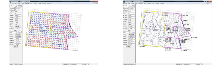
- Easily create single plane, or work with multi-plane designs
- Easily create contour banks
- Record terrain heights before and after each operation
- Show areas covered, and maintain job areas and times
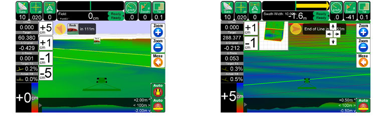
- Mark runlines for visual guidance or auto-steer capability
- Mark special features
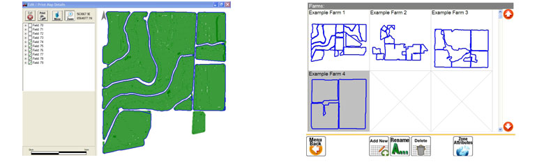
- Maintain multiple farm, field and job characteristics for full record-keeping
- Cross-levelling
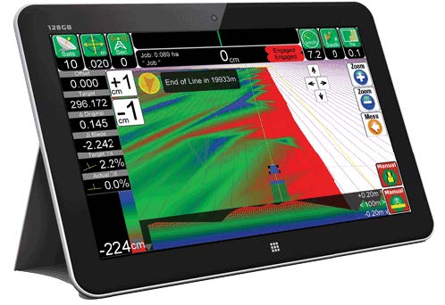
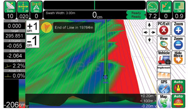
LEVELGUIDE’S FRONT SCREEN SHOWS ALL RELEVANT INFORMATION IN ONE STRAIGHT FORWARD FORMAT, INCLUDING:
A LEVELGUIDE DESIGN CAN BE CREATED USING FOUR TECHNIQUES
- Triple reference points (just mark 3 points then start working – it’s that easy!)
- Dual reference points, with designed cross-fall
- Single reference point, with designed main-fall and cross-fall
- Full multi-plane design using separate EziGrade software to generate a comprehensive cut-fill map
- LevelGuide can also be used to mark a rising or falling contour bank by marking a reference point and defining a slope
FREQUENTLY ASKED QUESTIONS
The advantages of using GPS . . .
over laser are that you are not limited to operating close to the base station you can move up 4km from the Base. A field design surface can be loaded into the PC for the controller to allow the blade to follow in the field. This can be a flat plane, a combination of planes or even a ‘curved’ surface for more undulating fields. The only boundaries are the field boundaries.
The vertical accuracy . . .
of the GPS is typically 10 to 15 mm. Combined with other inaccuracies associated with land levelling, such as hydraulic lag, tyre flexing, field trash and clod size, it’s on a par with or better than laser systems used in agricultural land levelling.
Distance from the Base
The vertical accuracy is affected by the distance the rover is operating from the base station. However up to about 4 km from the base station there is very little change in accuracy.
Field Designs
Levelguide is based around a cut and fill design package called Ezigrade and the Civil Design package, CDS. This package can be used to create simple designs with planes and ‘curved’ surfaces through to more complex ones with many multiple planes, banks etc.
Design Services . . .
Our Survey and Design Team in conjunction with other field designers can either create designs or help find a local designer who can do this for you.
Simple grading for building ditch pads and drains
There is no need to have a field design, levelguide can be setup simply like a laser by setting grades in the PC. The best part about this is this can be done from the tractor seat and these grades are stored in the PC so if you wish to return to this ‘design’ later on it is easy.
Other Design Packages
If you have field designs from other design packages these can be converted to go into Levelguide. These designs can be either digital or on paper but the base survey information needs to be in a digital format. Our Survey and Design Team and its associates have the capability of converting many different file formats so they can be loaded into Levelguide, some of these include 12D designs and Trimble designs.
AutoSteering and Levelling
These functions can both happen together if you wish. This requires 2 Rover GPS’s to be mounted one for autosteering the tractor with the antenna on the bonnet of the tractor and one for controlling the blade with the GPS antenna on the bucket.
What sort of implements can Levelguide be attached to?
Levelguide can be used on any implement with a blade. Hydraulics on the blade need to be external (not three point linkage). The Speed-Forma is a good match with the Levelguide system for your brushing/polishing and 3D dryland work and for bulky work the system can simply be transferred to a scraper/scoop.
What sort of hydraulics are required?
On larger later model tractors, such as Case, New Holland and John Deere the hydraulic remotes can be used to control the blade in automatic mode. With other brands of tractor a proportional valve will be required to operate the blade.
Can Levelguide be used manually?
Levelguide can be used either manually or in automatic operation. In the manual mode the operator follows the display on the screen to raise and lower the blade, in automatic mode the Agguide PC operates the hydraulics on the implement.